Sharing a Memo to Council featuring a detailed summary of the extreme weather event that occurred on July 1, 2026, its impact on City infrastructure and the community, and planned next steps.
The City recognizes the significant impact this rainfall event had on many residents, businesses, and communities. We appreciate the challenges and disruption faced by those affected and remain committed to learning from the event and identifying opportunities to improve community resilience.
Background
On July 1, 2026, the City of Ottawa experienced intense rainfall over a short period of time, along with high winds. The extreme weather event caused flooding and widespread hydro outages across the city. Initial weather and rainfall data was collected from the Ottawa International Airport, which houses Environment and Climate Change Canada’s local weather collection information. However, this data is not representative of the impact across Ottawa due to the city’s geography. City staff have since undertaken a more thorough assessment of the storm to understand the localized intensity and scope of the event.
Storm Characterization and Rain Gauge Results
The City of Ottawa maintains approximately 26 rain gauges throughout the city to measure how much rain falls and where it occurs. These gauges continuously monitor rainfall intensity and accumulation. Rainfall data collected by the City is routinely cross-referenced with Environment and Climate Change Canada radar data to provide a more complete understanding of storm event characteristics across the municipality. The information helps staff track storm events, understand flooding impacts, and manage and improve the City’s stormwater system.
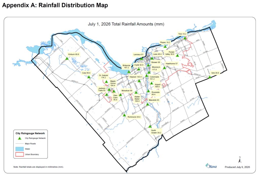
A Rainfall Distribution Map, Appendix A, illustrates the spatial distribution of rainfall across the City of Ottawa on July 1, 2026, based on preliminary (unverified) measurements from the City’s rain gauge network. The data show significant variability in rainfall totals across the city, ranging from as little as 15 mm at Trim Road in the northeast to as much as 167 mm at the Britannia station in the west-central area. The highest rainfall amounts were concentrated in central and western Ottawa, including Britannia (167 mm), Colonnade (151 mm), Nepean (144 mm), Mooney’s Bay (117 mm), and St. Gabriel (114 mm), while many eastern and rural locations recorded substantially lower totals. This pattern demonstrates the highly localized nature of the storm, with some neighbourhoods receiving more than ten times the rainfall recorded at other locations within the City.
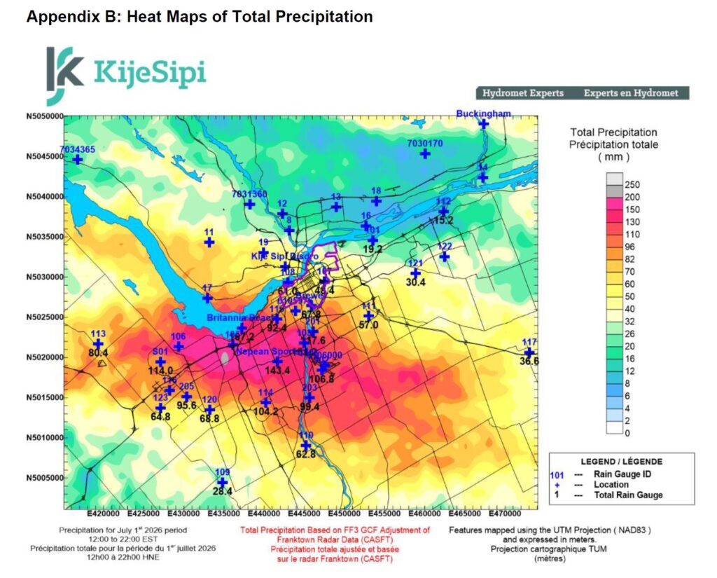
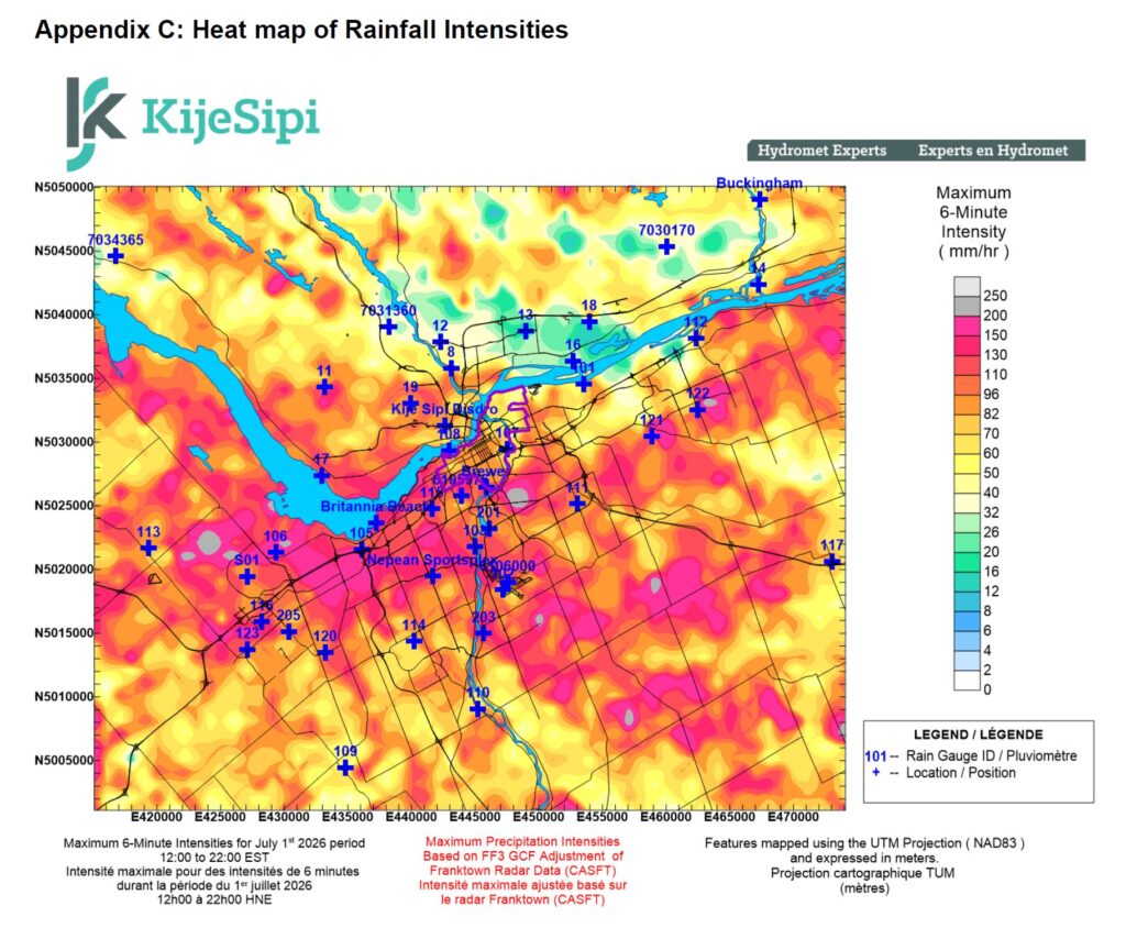
Appendix B and C are heat maps that show that the July 1, 2026 storm was concentrated over central and southwest Ottawa, where both the highest rainfall totals and the most intense rainfall rates occurred. Total precipitation generally exceeded 100 mm across portions of the urban area, while the highest 6‑minute rainfall intensities were also centered within the same corridor. Together, the maps indicate that the areas most affected by flooding experienced both exceptionally high rainfall volumes and intense short-duration rainfall, creating significant runoff and pressure on storm drainage systems.
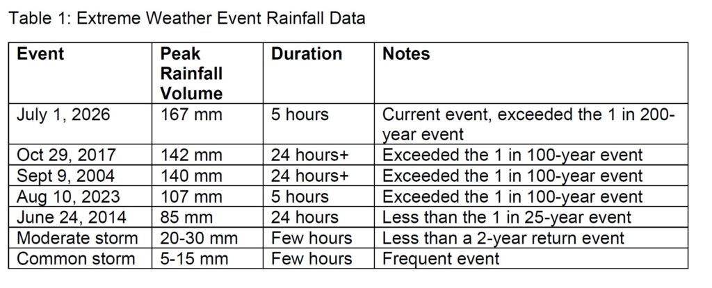
A common storm in Ottawa between the spring to fall period is often in the range of 5-15 mm total volume of rainfall, with peak storm intensities of 5 to 15 mm per hour. These usually have a duration of only a few hours. During the July 1 extreme weather event, many parts of the city experienced total rainfall accumulation of 50 to 150 mm of rainfall, including areas that experienced a storm event close to or exceeding a 1 in 200-year event. Table 1 below summarizes some of the major storms we have seen in the City of Ottawa, with comparison to the July 1, 2026 event.
Neighbourhood Impacts
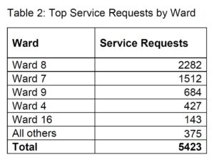
As of the morning of July 10, 2026, 3-1-1 received a total of 5,423 service requests related to flooding and other extreme weather event related impacts. When considered alongside rainfall gauge data, this information provides insight into the spatial distribution of storm impacts across the city and supports the identification of the neighbourhoods and wards most affected by the event. The geographic distribution of service requests is illustrated in Table 2 below. The highest concentrations of service requests were reported in Wards 4, 7, 8, and 9, indicating areas where residents experienced significant flooding-related impacts.
City Infrastructure Performance
Despite the extreme weather event, the City’s critical water and wastewater infrastructure remained operational throughout both the storm and the subsequent drainage period. Critical facilities, including the City’s drinking water system, wastewater treatment plant, pump stations, major trunk sewers, and emergency response systems, continued to function and provide core services. While these critical assets demonstrated resilience under severe conditions, the extraordinary volume and intensity of rainfall exceeded the capacity of many localized drainage systems, resulting in widespread flooding across affected areas.
As a result of this extreme weather event, sanitary sewers, storm sewers, and the broader drainage system in the most affected areas were over-capacitated by the intensity and volume of rainfall, while the surrounding ground conditions became saturated within a short period of time. The storm sewer systems across the city were operating over capacity, resulting in some stormwater traveling across the surface rather than through the pipe system. This led to significant surface ponding in low-lying areas and a significant number of basement flooding incidents and substantial combined sewer overflow.
Staff are working with the conservation authorities on the impacts to creeks, and the impacts those creeks had on local stormwater systems.
There are several possible entry points for water to enter basements. These include stormwater backing up through storm service connections, groundwater penetrating foundations through cracks and joints, surface water entering through doors and window openings, and sump pumps being unable to keep pace with inflow rates or failing due to power outages. Additionally, groundwater and stormwater entered and overloaded the sanitary sewer system.
Operational Response
City of Ottawa crews responded quickly to manage flooded roadways, clear debris and fallen trees from City infrastructure. First response crews have spent countless hours responding to 3-1-1 calls from residents reporting property flooding. City staff have responded to many maintenance calls and continue to assess the system to ensure the City’s linear infrastructure systems can function efficiently and drain flooded areas.
Resident Support
The City recognizes the significant impact this extreme weather event has had on residents, businesses, and the broader community, and extends its support to all those affected. Residents affected by flooding may also be eligible for financial assistance through existing City programs:
- Residential Protective Plumbing Program – Provides financial assistance to eligible homeowners for the installation of protective plumbing devices, such as sump pumps and backwater valves, to help reduce the risk of future basement flooding.
- Compassionate Grant Program – Provides financial assistance to eligible property owners and tenants who experienced basement flooding.
Residents are encouraged to review the eligibility requirements and submit any required flood reports and applications as soon as possible. If residents need support completing the forms, please contact the Compassionate Grant Program email address: compassionategrant@ottawa.ca.
Next Steps: Investigation and Technical Analysis
The City is undertaking a comprehensive review of this extreme weather event to better understand impacts, assess system performance, and identify opportunities for improvement.
In the near term, City staff will review flood-related service requests and where required, will contact residents to confirm details and gather additional information.
Over the coming months, City staff will undertake the following activities:
- Review previous flooding studies, historical flood records, and recommendations from past events.
- Document infrastructure and operational improvements that have been implemented and assess how they performed during this event.
- Prepare a summary report of flooding impacts across affected neighbourhoods including analysis of approximately 5,500 service requests. This will be supported by an engineering consultant.
Following completion of the review, the City will:
- Review recommendations for private-side and public-side improvements to the system.
- Assess the findings and identify priority areas for action.
- Evaluate cost-effective operational and stormwater improvements.
- Consider measures that support the City’s established flood protection objectives, including performance under major storm events and future climate change conditions.
The City will continue to provide updates as the review progresses and findings become available.